In part two, hidden symbols and invisible ink point to a long-lost fort in North Carolina. Jim Horn concludes the tale of discoveries made and discoveries to come.
Podcast (audio): Download (8.9MB)
Subscribe: RSS
Transcript
Harmony Hunter: Hi, welcome to the podcast, I’m Harmony Hunter. Last week we heard the story of the Lost Colony, one of history’s most outstanding mysteries. This week, Jim Horn joins us again to talk about the stunning new discoveries made on the John White map at the British Museum.
So for 400 years these little wisps of clues are all that exist to tell us about what happened to this settlement. There are just theories and speculation until the present day, when we have this map that surprises us with a piece of information that no one had noticed in 400 years. We’re talking about the John White map which used to exist in the British Museum?
Jim Horn: That’s right.
Harmony: That’s where it’s kept. Tell us the new investigation into this map and what was uncovered.
Jim: The John White map is one of the principal pieces of evidence from the period. It’s a beautiful watercolor, as you say, housed at the British Museum. It was drawn by John White in 1586. And we now have to think about what was its purpose, was it a record of the previous expedition or was it telling us something about the new expedition that was being planned for the following year?
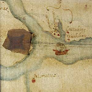
We, the First Colony Foundation, were interested in a couple of small patches that covered what might have been errors on the map – that’s what we thought initially – one to the south and one to the north right on that area that I’ve described as the confluence between the Roanoke and Chowan Rivers. They’ve never been investigated in any detail. I think the general assumption really was that they were simply covering up some kind of error in the painting or drawing of the map. But we thought it was worth a try, and actually we were more interested in the southern patch, initially, because we were looking to determine the exact location of an Indian village called Secotan so that we could maybe undertake some archeological work there.
But as it turned out, the most stunning evidence, new evidence, came from the patch at the head of the Albemarle Sound near the Roanoke and Chowan Rivers. And what we discovered there beneath the patch was a clear symbol of a fort. Without any question. We checked other symbols of forts from the same period, we liaised with the British Museum to do some detailed analysis of pigments in the paper to ascertain that this was indeed a contemporary symbol that had been drawn on the map -- that it wasn’t added much later. All that checked out so we know that John White had drawn that fort symbol at the head of the Albemarle Sound.
Harmony: What does that symbol look like?
Jim: It looks like a four-sided star, and it’s out of scale. If it was to scale it would cover many acres, but, but so we can’t necessarily determine the size of it, but it’s certainly consistent with other symbols of forts on maps of this period, right in line with those. Not too dissimilar, actually, to the earthwork we’ve already discovered at Fort Raleigh. So, no doubt in our minds that this is a fort symbol. And then the question is, “What does it mean?” Was there a fort actually there? And if so, it hasn’t been discovered archeologically? Or was it an intention to construct a fort there?
But just as we were pondering those questions, we also realized that there was not just one fort but two symbols of forts: one below the patch I’ve just described, but there was actually one drawn in invisible ink on top of the patch. This differed from the one beneath in a crucial way. It had a symbol of a fort rather smaller, but nevertheless, the same four-sided figure. But around it were parallel lines, vertical and horizontal lines, indicating palisades. In other words, this was not just a fort, but a fortified settlement that had been created and placed on top of that patch. So we were now faced with trying to figure out what was the sequence of events that led to drawing of the initial fort, then the patch going over the top of it and the new fort being placed on top of that.
And this is still open speculation, but I can give you my thoughts on it at the moment. We think the fort beneath the patch was drawn in 1586, at the time of the original map. We think it was either a small fortification at that location between the Roanoke and Chowan Rivers, or that the colony of 1585-1586 had intended to put a fort there but didn’t as it happened and yet that was considered to be a good location for such a fortification or maybe even settlement.
So that’s what John White was trying to indicate on the map. This would be another part of English territory along with the fort on Roanoke Island. One fort on Roanoke 50 miles further into the interior would be another fort which really determines the English possession of the region, not just an island. We think that John White was actually using the map. It would be a map that would be of use for the 1587 – the new expedition, the Lost Colony expedition&ndash and took the map with him to America.
Then when they discovered that they were running out of supplies on Roanoke Island, they hadn’t reached the Chesapeake Bay, they determined that John White should return to England. I think that some of their original thinking about the colony shifted. So that they still thought that maybe they should set up a settlement on the Chesapeake Bay, but that might be left to another group that would come from England that John White would recruit after returning. But the main group would move to that location of the fort symbol, but not just build a fortification, but actually build a settlement there where they would remain. And that’s the second symbol.
I think that it’s possible that when John White returned to England, this is what he was telling Raleigh, and this is what Raleigh was telling sponsors to raise a large expedition, which he did actually in the spring of 1588, a large expedition to return to Roanoke Island. So it’s a slightly complex sequence of events, but I think it might tell us that there was a shift in planning, and that the Roanoke region was going to continue to be settled even though the English still intended to settle, Raleigh intended to settle the Chesapeake Bay. The principal settlement in the Roanoke region would be that fortified settlement between the Roanoke River and the Chowan Rivers. So I think that’s where we are at the moment, but I should just underline much of this is we’re still working out what the implications might be of this discovery.
Harmony: But the significance of this type of discovery almost can’t be overstated. You found a map with a big red “X” marking the spot. Do you remember the day you first saw the map or the day you first heard the news?
Jim: Well it was, actually, and one of those “I can’t believe it” moments. In the work that I’d done as I mentioned earlier I was convinced that they had moved west. And not only that, but that there was a small creek, a small river near the big rivers. It’s called Salmon Creek today where they settled, at least initially, after leaving the island. And I mention that in my book. And lo and behold, when the British Museum were looking at the possible location of the fort, not only do they mention it’s right there at the confluence of the Roanoke and the Chowan but they also mention it possibly on Salmon Creek. So it was almost uncanny.
I couldn’t have scripted it better and the people that passed the message on to me told me quite rightly that I needed to sit down before I really looked at the information. It’s stunning; it’s a really stunning discovery, whatever it means. It’s a stunning discovery, and I think probably the most important piece of information that we’ve had, at least since that Zuniga map of 1607, one of the most important pieces of information since John White himself drew the map, and the clue was there all along right in front of us beneath those patches without us knowing it.
Harmony: Unbelievable. What happens now?
Jim: I think the principal task now is to continue looking at the map. We’re finding out other things not so dramatic, but nevertheless, more intense scrutiny of the map showing us a few new pieces of evidence we didn’t have: ships, little ships that had been on the original map that had been erased and so on. So small changes, but tell us a little bit about what was going on. But more importantly, I think the key here is archeology. And what we have in mind to do, First Colony, is to raise funds to investigate that area around Salmon Creek. It’s a fairly built-up area, there’s a golf course there, it’s a beautiful area actually right on the Albemarle Sound, housing development. But there are areas that haven’t been disturbed too much and we have got some clues already from previous excavations that there were some very early English ceramics that might date to the late 16th century from the area of Salmon Creek. So shortly we’re going to, within the next few months, we’re going to go back to that area and have an initial look and then build a campaign to establish a long-term investigation there.
Harmony: Well it sounds very exciting. I hope you’ll keep us up to date with your progress.
Jim:Yeah, I’ll be pleased to.
Harmony: If listeners would like to learn more about the story of the Lost Colony of Roanoke, pick up James Horn’s book A Kingdom Strange. Thank you so much for being here today.
Jim:You’re very welcome.